
Grant helps find what works in reducing runoff
Two small creeks that flow through the Kaukauna area may play a big role in cutting down on algae blooms and fish kills and cleaning up the Fox River and Green Bay.
Kankapot Creek runs south to north through Kaukauna parallel to Crooks Avenue and empties into the Fox River just west of 1000 Islands Environmental Center. Plum Creek (pictured above) drains the farm fields east of Kaukauna and empties into the Fox near Wrightstown.
They have been serving as a laboratory to test conservation practices that keep soil on the farm fields, reducing runoff of phosphorus and other nutrients. Fox-Wolf Watershed Alliance received a $4.2 million federal grant from the Environmental Protection Agency’s Great Lakes Restoration Initiative in 2015 to reduce the sediment and nutrient load going into the Lower Fox River Watershed. Working with the Outagamie and Brown county land conservation departments and the nonprofit Nature Conservancy, the federal money has funded the installation of conservation practices on farm fields in that area.
Researchers needed a better way to verify which erosion controls work best and communicate those results to each other. A $23,900 Bright Ideas grant from the Community Foundation provided them with a consultant (GISInc.) to help them develop a database tool to meet that need. (See a list of all grants awarded from the Bright Ideas Fund.)
“The funding from the Community Foundation allowed us to hire a consultant, which allowed us to take it to the next level. It’s a really exciting project,” Jessica Schultz, FWWA executive director, said
The database eventually will be used by soil conservation officials in Outagamie, Winnebago, Calumet and Brown counties to help track the cost of various conservation approaches and whether the results are as expected, based on water quality monitoring being done by the University of Wisconsin — Green Bay and the U.S. Geological Service.
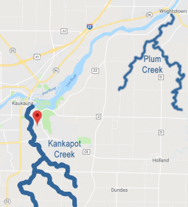 Plum and Kankapot creeks were selected because they have the highest sediment and phosphorus loading per agricultural acre of the 15 subwatersheds feeding into the Lower Fox River.
Sediment clouds the water and degrades fish habitat. Phosphorus feeds algae and other tiny organisms that consume oxygen from the water. Techniques for controlling the runoff include buffer areas against planting near streams, streambank protection, cover crops on corn fields and changing tillage practices. But which combination of conservation practices is best and how can you track and verify that over a large watershed?
The database tool developed with the help of the consultant, and funded by the Community Foundation grant, is helping Fox-Wolf and its partners to search for those answers more efficiently.
Team leaders have gotten inquiries about the database tool, including from soil conservationists in Shawano and Fond du Lac counties and Milwaukee.
“We’re getting all of the bugs out now,” Schultz said. “There’s a potential that it will help the state, not just the region.”
Sign up to get in The Loop.
Invite a friend to get in The Loop.
Leave a Comment